| |
|
The southern extremity of the historic centre of Florence, on the hydrographical left side of the Arno river, is bordered by a series of hills, known as Colli Fiorentini, which yield a suggestive panorama of the city with its artworks and monuments [2].
The San Miniato hill (also known as Monte alle Croci or Mons Florentinus) represents the most famous of these gentle heights, for its landscape significance and for the monuments of inestimable cultural, historic and artistic value [2]. Between 1865 and 1876, in coincidence with the designation of Florence as temporary capital of the Reign of Italy, the hill was involved in a radical town-planning transformation directed by the architect Giuseppe Poggi. On the San Miniato hill, Poggi designed the scenographical Viale dei Colli with its panoramic open squares, of which Piazzale Michelangelo is the most famous [2].
Lungarni (riverside walkways) were built on the riversides. On the right bank, the fourteenth-century city walls were removed and turned into the Viali di Circonvallazione, mimicking the French "boulevard" design, six lanes wide and lined with trees. On the left bank winding up the hill of San Miniato the Viale dei Colli was built, a tree-lined street over 8 kilometers long ending at the Piazzale Michelangelo which was built as a terrace with a panoramic view of the city.
|

|
A view of Florence, Viale dei Colli [1]
|
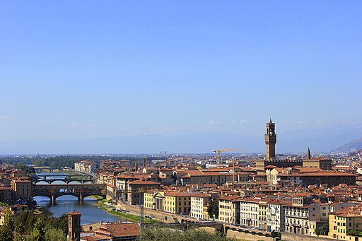
The famous panoramic terrace, known as Piazzale Michelangelo (1865-1876) is located in the central part of this slope, connected to the city through a complex system of artificial terraces, waterfalls and masonry walls (le Rampe) accommodating the roadway.
Piazzale Michelangelo and the loggia
The square, dedicated to the Renaissance sculptor Michelangelo, has bronze copies of some of his marble works found elsewhere in Florence: the David and the four allegories of the Medici Chapel of San Lorenzo. The monument was brought up by nine pairs of oxen on 25 June 1873.
Poggi designed the loggia in the neoclassical-style that dominates the whole terrace, which today houses a restaurant. Originally it was intended to house a museum to hold the other masterpieces of Michelangelo. The museum was never realized. In the wall of the balcony, under the loggia, there is an epigraph in capital letters referring to his work: Poggi turned this into his monument in 1911.
Poggi devoted the most unstable zones of the area, including the terrace today used as a campsite, to public gardens [3]. Along the Viale dei Colli Poggi provided gardens with arbors and chalets that at the time offered "all kinds of recreation". One of these gardens was the Giardino delle rose (The Rose Garden).
|
|
|
|
| |
|
From Piazzale Michelangelo you can enjoy the most beautiful panorama of the city, with views of the Ponte Vecchio, the Duomo Santa Maria del Fiore, the Uffizi, Santa Croce and the Palazzo Vecchio.
|

|
| Panoramic View of Florence from Piazzale Michelangelo [4]
|
Giuseppe Poggi and the urban renewal of Florence |
|
|
Viale dei Colli is an approximately 6 km long panoramic road that stretches from the Porta Romana to the Ponte San Niccolò and was designed and realized by Giuseppe Poggi in the short period that Florence was the capital of Italy (1865-1871). The architect meticulously described them in the seventh chapter of his report on the extension of Florence. He deliberately designed 'picturesque' effects, right down to the promenade to the church of San Miniato al Monte and the Cimitero delle Porte Sante cemetery. The Piazzale Michelangelo has been conceived as the highlight of the Viale dei Colli.
Along the walking route, which has a slope between 1 and 3.8%, Poggi provided some gardens with arbors and chalets that at the time offered "all kinds of recreation". One of these gardens was the Giardino delle rose (The Rose Garden).
|
|
 Viale dei Colli and panorama of Florence in a nineteenth-century photo Viale dei Colli and panorama of Florence in a nineteenth-century photo
|
 |
|
![La rampa di San Niccolò, [Archivo Alinari]. Nel riquadro la basilica di San Miniato, la chiesa ed il convento di San Salvatore ed il Piazzale Michelangelo collegato al Lungarno attraverso le Rampe [Foto di Giacomo Brogi]](https://lh3.googleusercontent.com/R-bjixWFosWs13pbTYm3DNdySxQnM0k9I1BXS4Hj1sdhWvFWrtqE99S8Dm8ED4m-MUV3bDPnj_DiOGkXT9Quuj3If1LXfEKCxOfHJRMrGrtLvY2MNCn-iuJfhY2xa-euHMt4zsMe6g=w800) |
|
 |
Sommer, Giorgio (1834-1914) - n. 3516 - Firenze - Piazza Michelangelo
|
|
La rampa di San Niccolò, [Archivo Alinari]. Nel riquadro la basilica di San Miniato, la chiesa ed il convento di San Salvatore ed il Piazzale Michelangelo collegato al Lungarno attraverso le Rampe [Foto di Giacomo Brogi]
|
|
Tivoli, parco divertimenti realizzato nel 1869 sul Viale de' Colli fra Porta Romana e il Piazzale Galileo a Firenze |

Florence, Photo gallery
|
|
|
![Piazzale Michelangelo [Magnificent View on Ponte Vecchio]](https://upload.wikimedia.org/wikipedia/commons/thumb/4/4f/Florence_from_Piazzale_Michelangelo_-_panoramio_%286%29.jpg/512px-Florence_from_Piazzale_Michelangelo_-_panoramio_%286%29.jpg) |
|
 |
|
 |
Piazzale Michelangelo [Magnificent View on Ponte Vecchio]
|
|
Piazzale Michelangelo, con veduta del Duomo di Santa Maria del Fiore |
|
Panoramic view from Piazzale Michelangelo on Santa Croce |
 |
|
 |
|
 |
Piazzale Michelangelo |
|
Piazzale Michelangelo, con veduta del Ponte Vecchio e di Palazzo Vecchio
|
|
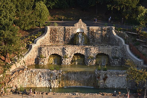
Fontane delle Rampe del Poggi, Firenze |
 |
|
 |
|
 |
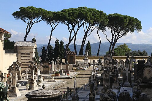
San Miniato al Monte, Cimitero Porte Sante
|
|
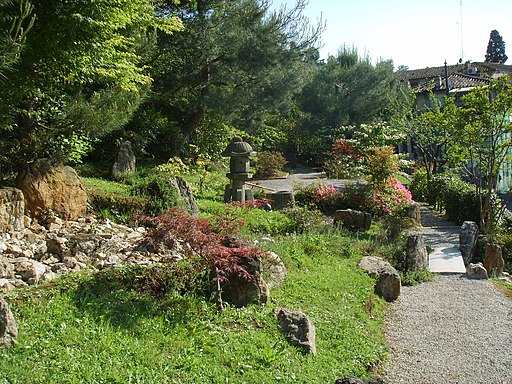
Giardino delle rose, Firenze |
|
Giardino delle Rose, Oltrarno, Firenze
|
 |
|
|
|
|
| |
|
|
|
|
Strolling in Florence | Walk from Ponte Vecchio to Piazzale Michelangelo
Beautiful walk in one of the most authentic neighborhoods of Firenze, San Niccolò. The atmosphere of an authentic Florentine neighborhood still remains here.
|
|
 |
| |
|
Giardino Bardini, View east inbetween Porta San Niccolo and Piazzale Michelangelo
|
Transport
Instead of walking up, you can also take bus n ° 12 from Piazza Romana, or bus n ° 13 from piazza Giuseppe Poggi (San Niccolò).
Timetables and routes - ATAF | Map
You can view the bus routes at the Florence transit site: www.ataf.net/en/ataf.aspx?idC=2&LN=en-US
|
|

|
| |
|
|
|
Bus trasport in Florence
|
Bibliography
Giuseppe Poggi, Sui lavori per l'ingrandimento di Firenze, G. Barbèra, 1882
Rinaldi, Niccolò (2012). "Rose Garden". Secret Florence. trans. Jeremy Scott (2 ed.). Versailles: JonGlez. p. 286. ISBN 9782361950446.
Agostini, G. & Casagli, Nicola & Delmonaco, Giuseppe & Fanti, Riccardo & Focardi, P. & Margottini, Claudio. (2002). Landslide Monitoring and Cultural Heritage At Risk: The Case Study of San Miniato Hill In Florence.
CRIBARO, CHRISTOPHER DANIEL, "URBAN PLANNING AND ADMINISTRATION IN FLORENCE: 1400-1600" (1980). ETD collection for University of Nebraska - Lincoln. AAI8100422 | digitalcommons.unl.edu
"Giardino delle Rose". Diladdarno: Firenze oltre il fiume. Retrieved 19 May 2016.
Montanari, Laura (29 September 2011). "Nel giardino delle visioni l'ultimo desiderio di Folon". Repubblica (in Italian).
|

[1] Foto nel Pubblico dominio.
[2] Agostini, G. & Casagli, Nicola & Delmonaco, Giuseppe & Fanti, Riccardo & Focardi, P. & Margottini, Claudio. (2002). Landslide Monitoring and Cultural Heritage At Risk: The Case Study of San Miniato Hill In Florence.
[3] 'The implementation of the project lead to a general modification of the slopes profile, with excavations and fillings involving impressive earth movements, the building of drainage systems and canalisations which supplied water for the waterfalls and fountains, and the construction of a series of earth retaining structures along the boulevard and on the Rampe terraces.
(...)
The most unstable zones, including the area today used as a campsite, were devoted to public gardens; the Rampe system was planned and built with the main role of supporting the unstable slopes and the weight of the filling material of Piazzale Michelangelo through a series of retaining walls; Piazzale Michelangelo was made using the wall built in the 16th century by Michelangelo, both for static and economic reasons; the monumental staircase, besides an architectonic function, was erected for rearranging the slope profile, affected by small but persistent instability phenomena (Poggi 1882).'
Agostini, G. & Casagli, Nicola & Delmonaco, Giuseppe & Fanti, Riccardo & Focardi, P. & Margottini, Claudio. (2002). Landslide Monitoring and Cultural Heritage At Risk: The Case Study of San Miniato Hill In Florence, pp 3-4.
[4] Foto di Pierre Selim Huard, licenziato in base ai termini della licenza Creative Commons Attribuzione-Condividi allo stesso modo 3.0 Unported
|
| |
| Poggi city plan, from: "Sui lavori per l'igrandimento di Firenze, Relazione di Giuseppe Poggi (1864-1877)", Barberà, Firenze 1882 |
|
|

.jpeg#/media/File:Panoramic_View_Of_Firenze_(157422347).jpeg)
![Piazzale Michelangelo [Magnificent View on Ponte Vecchio]](https://commons.wikimedia.org/wiki/File:Florence_from_Piazzale_Michelangelo_-_panoramio_(6).jpg)

_-_n._3516_-_Firenze_-_Piazza_Michelangelo.jpg)