| |
|
 |
 |

|
N L E N G |
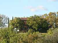
Panorama of Montisi, seen from Via degli Ortali1]
|
|
![Toacana ] Galleria di immagini](../../titels/albump.gif) |
|
| |
 |
|
|
| |
|
Trekking in the Crete senesi | Percorso di trekking Trequanda | Anello Montisi - Montelifrè
|
|
|
|
| |
|
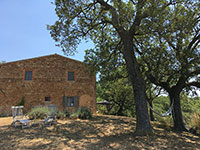
Podere Santa Pia is a beautiful stone farmhouse in southern Tuscany. Located on the outskirts of Castiglioncello Bandini, in a hilly and unspoilt land, Podere Santa Pia is one of the best places to slow traveling in Tuscany. This formal cloister offers the quiet tranquility of a private retreat, with numerous attractions and beautiful nature reserves within easy reach. The most interesting artistic, historical and cultural sites of southern Tuscany are nearby, and are awaiting your discovery.
Biancane or badlands in the Crete Senesi
Just across the border of the Val d’Orcia, but still within the spectacular panoramic scenery of this World Heritage site, is the circular walk from Montisi to Montelifrè, an itinerary in the great scenery of the Crete Senesi, just about 70 km north of Podere Santa Pia. This is a veryshort but very suggestive itinerary. In addition to the visit of Montisi, a town with a beautiful historic center, and the ruined Castle of Monelifrè, the trail offers panoramic views of the Crete Senesi. The departure and the arrival are foreseen in in Montisi, where it is possible to park and shelter from the sun.
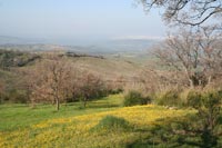
The magnificent hills of the Crete Senesi offer endless views with evocative and suggestive landscapes. Typical conformations of the land are the badlands, the calanchi and biancane that give the landscape its characteristic gray color and a sometimes lunar appearance.
Download gpx here
Lenghth: 9,59 km, about 2 hours
Total climb 532 m
Total descent 532 m
This itinerary starts and ends in Montisi.
|
|
|
|
| |
|
|
|
| |
|
This evocative itinerary covers the hills of the Crete Senesi in the Municipality of Montalcino (until 2016 San Giovanni d'Asso was an independent comune) and offers spectacular views of the clay hills with colors and light changing from hour to hour, and from season to season.
|

|
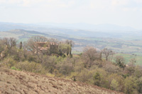
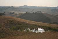
| Castello Montelifrè, entrance lane [1]
|

Galleria fotografica Montelifrè e Montalcino
|
|
|
 |
|
 |
|
 |
Ruins of Montelifrè
|
|
Montelifrè
|
|
Veduta al tramonto di Montelifrè, in provincia di Siena, dalla strada per Montisi
|

|
|
|
 |
|
 |
|
 |
| |
|
Crete Senesi (laghi tra Castello Leonina e Vescona, Crete Senesi, Asciano)
|
|
Paesaggio tra le Crete senesi e la Val d'Orcia
|
 |
|
 |
|
 |
Crete Senesi presso Asciano
|
|
Deserto di Accona
|
|
Biancane nelle Crete Senesi vicino a Monte Oliveto Maggiore
|

De badlands van Toscane | Calanchi e biancane | Un tesoro della natura
Het unieke landschap van de Crete Senesi`
Crete Senesi | Biancane nelle Crete Senesi
Trekking in Toscana | The Crete Senesi
Montalcino - Buonconvento - Abbazia Monte Oliveto Maggiore | 27 km | 5,5 hours circa
Buonconvento - Abbazia Monte Oliveto Maggiore | 11.60 km
Anello Chiusure - Monte Oliveto Maggiore, Asciano | 5,64 km
Buonconvento - San-Quirico-d'Orcia | Via Francigena | 17 km
Siena - Ponte d'Arbia - Buonconvento | Via Francigena | 26 km - 5 hours
Corsano - Ponte d'Arbia | 19 km
From Montalcino to Buonconvento | 16 km | 3 hours circa
Trekking in Trequanda | Anello Trequanda – Petroio – Montisi – Montelifré | 18 km - 3h 39m

Vakantiehuizen in Toscane 
Podere Santa Pia is a beautiful stone farmhouse only 2 km away from Castiglioncello Bandini. The main house is spacious, comfortable and well furnished and offers its guests a breathtaking view over the Maremma hills. Podere Santa Pia is surrounded by a backdrop of hills and macchia mediterranea: wild, untamed and completely natural vegetation, wonderful for walking and exploring on a variety of different terrain with fantastic views everywhere you turn.
Montisi and the Crete Senesi are located north of Podere Santa Pia. The suggestive road to Montisi goes along the abbey Sant'Antimo, Montalcino and Sant'Anna in Camprena.
Traveling in Tuscany| Holiday homes in southern Tuscany | Podere Santa Pia
|
|
|
|
|
 |
|
|
|
|
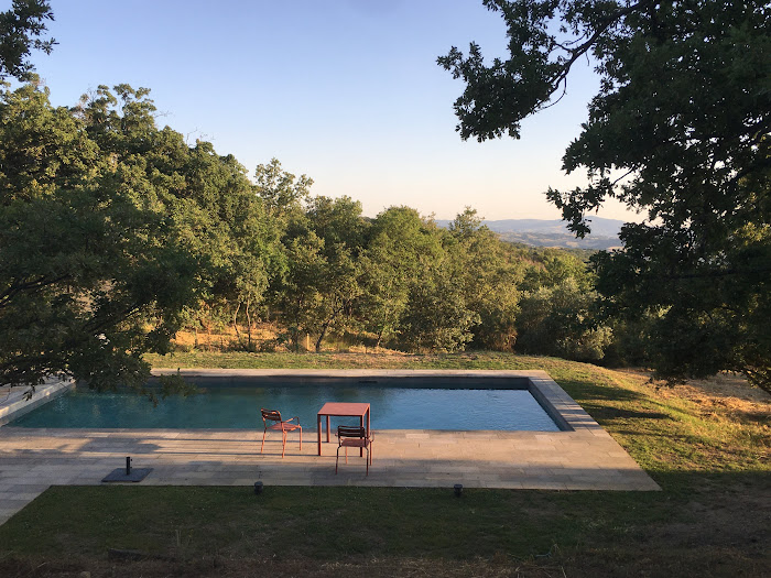
The night pool at Podere Santa Pia exudes a hypnotic sense of purity
|
|
|
 |
|
 |
|
|
Podere Santa Pia
|
|
Magiche colline circostanti
|
|
|
 |
|
 |
Celebrare il dolce far niente
|
|
A beautiful early evening by the pool, in the resplendent Tuscan sun, time takes on a languid quality
|
|
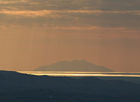
Visia da Podere Santa Pia, fino al mare e Montecristo
|
 |
Reflections on the pool: Tuscan designs for swimming
|
‘And then, suddenly, a view opens up. The hills recede, slowly and cautiously. You stand still, as if to leave would be a betrayal.’
|
 |
La Maremma Toscana e l'Area del Tufo, l'antichissimo territorio abitato da Etruschi [2]
|
| |
|
|
|
|

[1] Photo by Pufui Pc Pifpef I, released in the Public Domain, Collegamento
[2] Photo by aurelio candido, published under a Attribution-NonCommercial-NoDerivs 2.0 Generic (CC BY-NC-ND 2.0) license.
Montisi, map
|
|
|
|
| |
|
|
|
| |
|
|
|
| |
|
|
|
| |
|
|
|
| |
|
|
|
| |
|
|
|
|