| |
|
 |
 |

|
| I T |
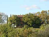
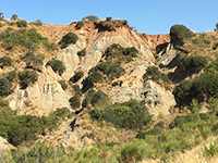
Biancane in the Accona desert, Crete senesi, view of the side of Le Fiorentine, facing Leonina
[1]
|
|
![Toacana ] Galleria di immagini](../../titels/albump.gif) |
|
| |
 |
|
|
| |
|
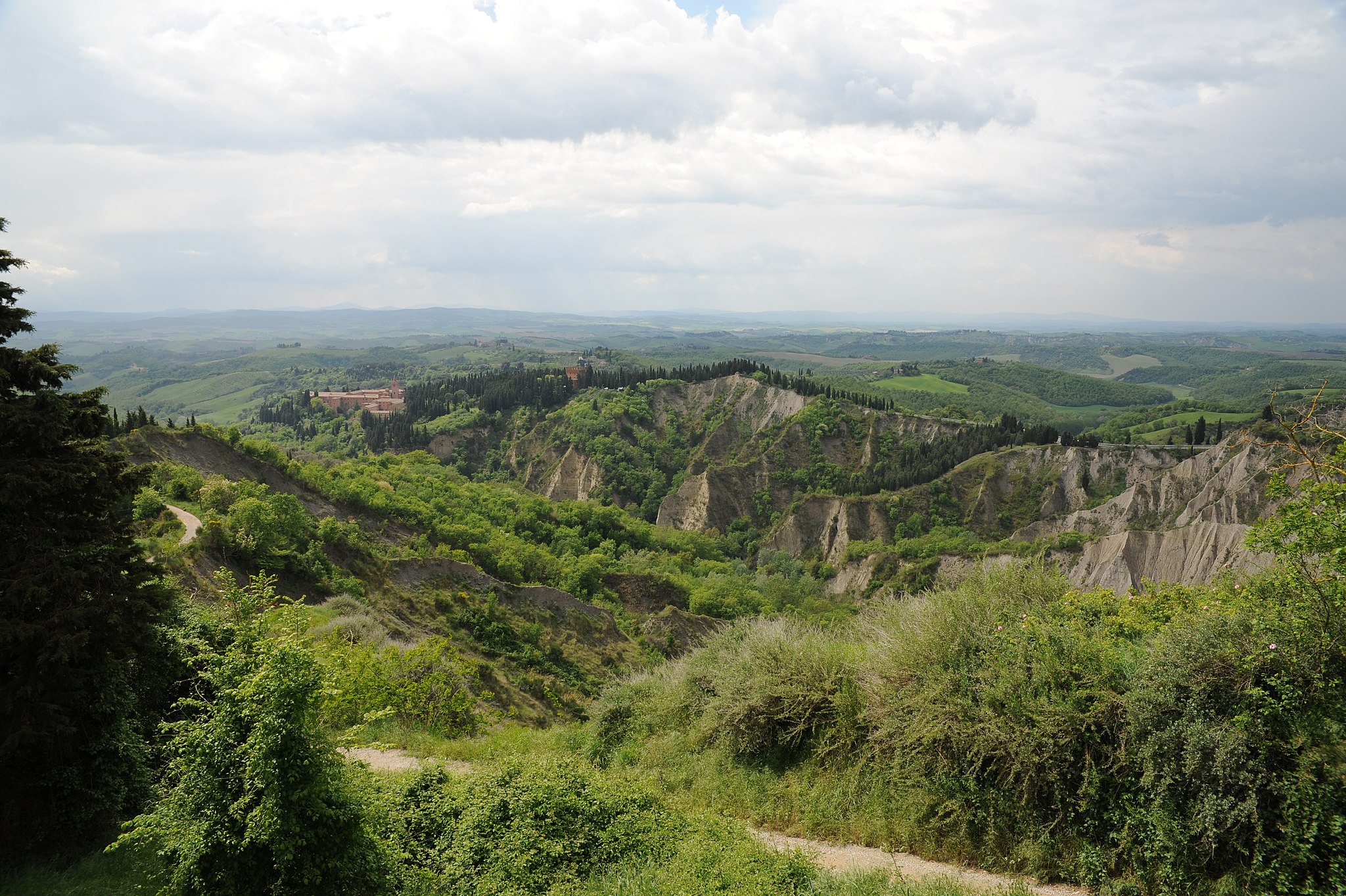
Crete Senesi, Biancane and calanchi in the Accona desert
|
|
|
|
| |
|
Accona desert refers to a hilly area in the Siena province of Italy, within the municipality of Asciano [43°14'4.30"N; 11°33'37.48"E] often enlarged to include the biancana site of Le Fiorentine - Leonina [43°17'32.95”N; 11°26'54.07"E]. [2]
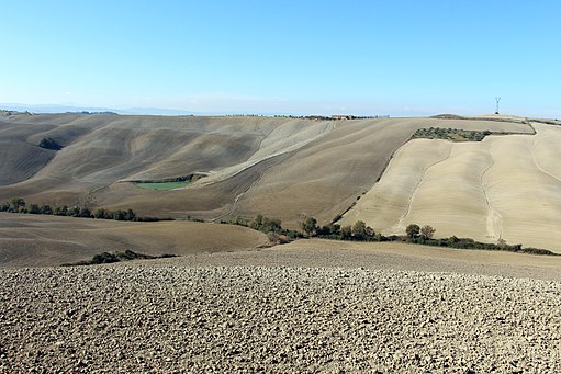
The territory between Buonconvento, Asciano and Montalcino was known in the Middle Ages as the edge of the Accona desert. The area was the backdrop of the Tyrrhenian Sea in the Pliocene. In that era the clay layer was formed which today mainly characterizes the ground. There is also the presence of rock salt and gypsum, called mattaione, which gives the typical "lunar" aspect to biancane and calanchi which in the past totally discriminated the territory of the Crete Senesi but more recently is found only in much more limited areas due to the activities anthropogenic that have tended to convert the land to agricultural activities and livestock. Currently only some areas have widely preserved their original natural characteristics.
The particular morphology and composition of the soil made it difficult to cultivate vines and olive trees; the crops practiced are those of wheat, sunflowers and fodder thanks to the centuries-old anthropic works that have partly modified the original landscape aspect and the intense irrigation activity that exploits the waters of the fountains and streams that flow there.Leonina [43 ° 17'27.11 "N; 11 ° 26'40.01" E] and Lucciola Bella [43 ° 2'4.85 "N; 11 ° 45'35.75" E] are two of the best places to walk among the biancane, while Chiusure - Monte Oliveto Maggiore (i.e. ancient Accona; [43 ° 10'40.21 "N; 11 ° 33'7.85" E]) and Radicofani [42 ° 55'8.14 "N; 11 ° 44'38.82 "E] are characterized by the most interesting ravines.
The biancana badlands, a typical element of the southern Tuscany landscape, were in expansion for centuries, until bulldozers began erasing them for land reclamation purposes. Over the last 10–15 years some of the scattered remnants of biancanas have been placed under protection in order to preserve their biodiversityand their particular cultural and geomorphological landscapes. Rural abandonment and the lack of appropriate management practices have contributed to vegetation encroaching on biancana badland slopes, causing a loss of elements of high ecological and cultural values, as well as eroded spots.[18]
|

|
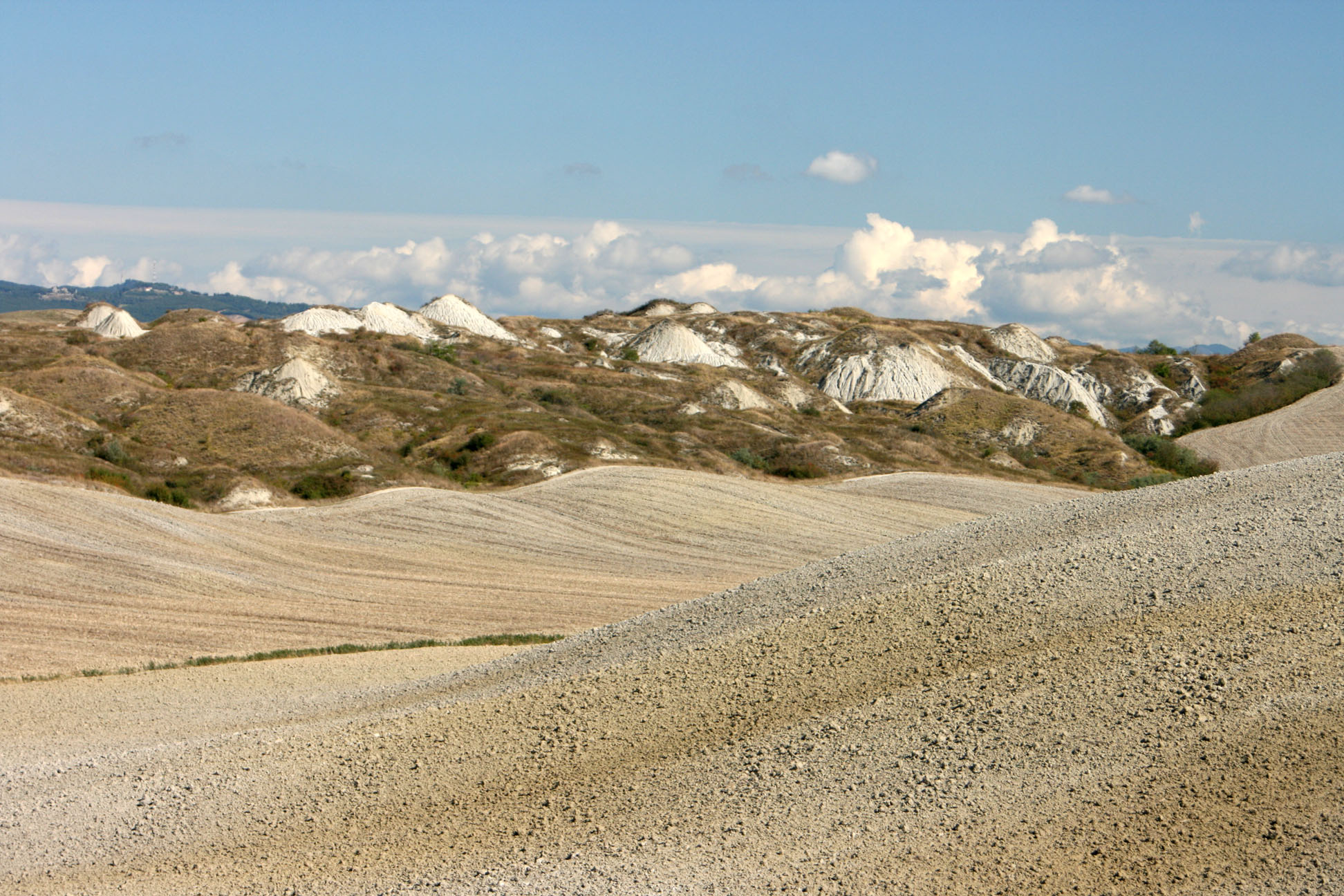
Vista ravvicinata di alcune biancane nel sito Leonina [1]
|
Characteristics
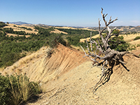
Two main types of badlands [5] can be found in the area of the Crete Senesi, the Valdorcia and the Volterra areas of Tuscany: biancana (from bianco, white, due to the light color of the clay and of the saline efflorescence) and calanco (local name for a type of gully, a sort of ravine). Both are linked to processes of gully erosion, the former intermingled mainly with subsurface erosion and the latter with mass movements. Biancanas can be found also in Basilicata and in Calabria. The calanco landscape is common all along the Apennines and in many parts of the Alps. Both calancos and biancanas were used as grazing ground, with an almost annual burning of the vegetation in order to remove brush and favour herbaceous cover more palatable for sheep, goats and cattle. Both practices were abandoned in the 1990s to favour measures to preserve biodiversity and geoforms under the EU Natura 2000 programme. Conservation has almost stopped erosion in both types of badlands and vegetation now covers the majority of the once bare slopes. As there is a strong interrelationship between vegetation biodiversity and erosion/deposition processes, biodiversity is also currently threatened and the biancana landscape is forecast to disappear completely within 20–40 years as brush cover expands.[6][7][8] Spots where the traditional forms can still be observed are dispersed in the Crete Senesi and the Valdorcia, included within the quadrangle of vertices [43°16'10.58"N ; 11°15'59.30”E], [43°18'28.68”N; 11°39'4.92”E], [42°43'32.58”N; 11°42'22.98”E], [42°45'49.22”N; 11°58'41.90”E]. Leonina and Lucciola Bella [43° 2'4.85"N; 11°45'35.75"E] are two of the best sites for walking through the biancanas, while Chiusure - Monte Oliveto Maggiore (i.e., the ancient Accona) and Radicofani [42°55'8.14"N; 11°44'38.82"E] host the most impressive calancos.
|
 |
Calanchi in the Accona desert, Crete Senesi, Monte Oliveto Maggiore, Chiusure [8]
|
History
Archaeological maps of Siena province show that all the Crete Senesi area was inhabited in Etruscan and Roman Times as almost every slope contains remnants of that period. The periods of the Barbarian invasions, the Gothic wars and the Justinian plague caused a demographic decline which reduced the anthropic impact on the environment and favoured the natural reforestation of the area. Nevertheless in the seventh century Asciano was already a Curtis Regia,[9] hence a village with a territory where agriculture and animal husbandry coexisted with hunting reserves used by the Lombard lords. In the tenth century documents show Leonina too as Curtis.[6] Other documentation, even if fragmentary, testifies to the existence of a stable settlement in Leonina.[11][8] At the time of the Black Death, (1348 with several return of the plague in the following 60–70 years [13][14] ) Leonina’s population halved from more than 150-160 to about 60 at the beginning of 1400. This fate was common to Siena, Asciano and the whole territory of the Sienese Republic: Siena’s population fell from about 50,000 before the Black Death to 14-16,000 in 1400-1450[11] (Ginatempo, 1990) and returned to pre-plague levels only at the end of twentieth century.
Asciano, with its surroundings, was a major town in the Sienese territory[12] for a long time and contributed to the Republic’s economy in a substantial way, gaining Sienese citizenship in 1369.
|
|
|
|
| |
|
|
Map Accona desert (Crete Senesi) | Ingrandire mappa
Accona desert refers to a hilly area in the Siena province of Italy, within the municipality of Asciano [43°14'4.30"N; 11°33'37.48"E] often enlarged to include the biancana site of Le Fiorentine - Leonina [ 43°17'32.95”N; 11°26'54.07"E] [8].
|
|
|
| |
|
The area of the Accona desert was known with this name since the Middle Ages and was also depicted in the frescoes of the Good Government of the town hall of Siena where Lorenzetti divides the city from the initially fertile countryside with clay walls until it leaves room for the Accona Desert. In the Middle Ages, on the southern edge of the Accona desert, the Abbey of Monte Oliveto Maggiore was built, initially intended as a hermit. The The Olivetan Benedictine monks, planted cypresses around the Abbey for decades, because it was the only way to consolidate the stability of the ground and avoid landslides.
|
 |
Ambrogio Lorenzetti, ciclo di affreschi "Allegorie del Buon e Cattivo governo" nella Sala Consiliare dei Nove, Palazzo Pubblico a Siena, scena: Effetti del buon governo sulla campagna [7]
|
A few kilometers south of Asciano the small town of Chiusure grew around the seventh century church of Sant’Angelo in Luco, despite the fact that the hill on which the village is located would have been threatened by the approach of the heads of large (and deep) gully systems retreating upslope. It had an economy mainly based on agriculture and animal husbandry. Chiusure's importance is due mainly to its proximity to Accona about 1 km away. The members of three leading Sienese families (Tolomei, Patrizi and Piccolomini) founded in 1313 what became the Benedictine monastery of Monte Oliveto Maggiore (1320-1344) on the site of the Tolomei’s Accona podere (farm).[17] Pius II (Enea Piccolomini) visited the monastery during his papacy (1458-1464) and described the area as rich in olive trees, fruit trees, almonds, vines, orchards, small cypress woods, oaks and junipers. Furthermore, Pius II added, there was water: a perennial spring, wells, tanks, cisterns.[17]
From this time until 1796 the monastery played a spiritual and economical leadership role in the area with its churches, monasteries and farms. Then, under French rule from 1797 all the Church possessions were confiscated and sold. Only after the Restoration did the Olivetan Benedictines recover the Monastery of Monte Oliveto and slowly resume their role as local leaders.
|
 |
Crete Senesi e l'Abbazia di Monte Oliveto Maggiore [14]
|
The environment and the anthropic influence
The first half of the fourteenth century was characterized by social unrest due to the transformation from farmers who owned their land to large land holdings with the property subdivided into poderi each managed by a farmer (mezzadro) and his family living on the fields in a cropsharing system.[22] At the same time foreign armies (e.g. Henry VII’s, mercenaries) passing through the Sienese territory interfered with normal activities in the countryside. Hence, erosion and floods are testified in several documents,[19][24]in the Lorenzetti’s Buongoverno frescos (1340), that show biancanas, while severe floods are reported.[23] Also the climate was characterized by droughts and extreme events[23][25]that led to a shortage of food in Italy and necessitated imports from abroad. This forced Siena to invest a large part of its wealth in facing these difficulties, thus diverting funds from other priorities such as flood prevention.
The second half of the fourteenth century the abrupt and large demographic decrease due to the plagues resulted in the farming population of small owners and mezzadri having to manage twice as much livestock and land per capita. With no resources for maintenance activity, the only use for a severely eroded field was animal grazing. Hence, the eroded fields became irrecoverable. The lack of personnel persisted for about two centuries during which the eroded areas expanded, reaching a maximum in the nineteenth century.
|
 |
Gli splendidi dintorni di Monte Olivetto Maggiore e Crete di Asciano [26]
|
This picture is substantially confirmed by soil denudation rates as estimated using average erosion in the basin of the river Ombrone which drains the area and on the denudation rates of the two largest biancanas of the Leonina site and the gully in between.[5]
Biancana badlands reclamation began at the end of the XIXth century and ended during the second half of the twentieth century when bulldozers removed almost all the biancanas and some of the smallest calancos, encouraged by EU subsidies then available under the Common Agricultural Policy.[22][27] Thus it can be said that damage mainly due to an epidemic (Black Death) was eventually solved by the EU-CAP of 1960-2000.
The Accona Desert
The natural and social history of the Crete Senese does not leave much room, both temporal and spatial for any physical desert. Nevertheless there certainly were large areas that progressively became severely eroded and devoid of vegetation.The Accona podere when Bernardo Tolomei retired there in 1313 may have been in poor conditions, certainly without any mezzadro. Hence, in all likelihood the desert of Accona referred at first to the absence of farmers in Accona and/or the lack of a strong spiritual leadership, a role that the Olivetans had filled. Later, in 1830-50 when the badlands were at their maximum, the label “Accona desert” was adopted by scholars and learned persons[28][25] to convey the feeling of desolation felt when in the midst of the biancana fields or the calanco gullies.
|
|
Deserta di Accona, veduta del versante de Le Fiorentine, di fronte a Leonina [7]
|
Charles Dickens' lively diary Pictures from Italy describes the landscape as 'a rather bleak country …a region gradually becoming bleaker and wilder until it became as bare and desolate as any Scottish moors. …a country as barren, as stony, and as wild, as Cornwall in England… When we got on the mountain pass … the wind …was so terrific, that… this land-storm might have competed with an Atlantic gale, … The blast came sweeping down great gullies in a range of mountains on the right: so that we looked with positive awe at a great morass on the left, and saw that there was not a bush or twig to hold by”.[19]
|

Tuscany is the undisputed protagonist in the world tourism panorama. The landscapes, the artistic heritage and the important cities make this region unique in the world.
Iimmersed in the splendid countryside of the Maremma countryside, surrounded by the aromas of the Mediterranean scrub, Podere Santa Pia is located in a fortunate hilly position from which you can enjoy a 360 ° view that will leave you breathless, an exceptional panorama up to the sea and Montecristo Island.
And these landscapes - as the poet Giuseppe Ungaretti wrote “mi illuminarono di immenso”, roughly translatied as I flood myself with the light of the immense, or I'm lit / with immensity.
Turismo in Toscana | Case vacanze | Podere Santa Pia
|
| |
|
|
|
|
|
| |
|
|
|
 Follow us on Instagram Follow us on Instagram
|
 |
|
 |
|
 |
Castiglioncello Bandini, Calanchi nella valle tra Podere Santa Pia, Federano e il torrente Rancida
|
|
Calanchi nella valle sotto Podere Santa |
|
Calanchi nella valle sotto Podere Santa |
Trekking in Toscana
Castelnuovo Berardenga, tra il Chianti e le Crete Senesi | Anello delle Biancane di Leonina
Hiking track around the Leonina Lake, starting in Castelnuovo Berardenga Scalo, Percorso di trekking Castelnuovo Berardenga | Anello delle Biancane Leonina.
There is a shorter track around the Leonina Lake, starting at the Parking at the SS Lauretana, Anello tra i calanchi e le biancane di Castello Leonina (Asciano).
Anello Asciano | 10,63 km | gpx
Anello Chiusure - Monte Oliveto Maggiore, Asciano | 5,64 km
Biancane of badlands in de Crete Senesi, een wandeling langs de laghetti van Santa Caterina en Menchiari | 12,66 km - 2,5 hours
Trekking in Toscana | Anello La Foce di Chianciano – Riserva di Lucciola Bella – Palazzone – Castelluccio
|
|
| |
|
|
|
Anello Lucignano d'Asso - Cosona - Torrenieri | Paesaggio tra le Crete senesi e la Val d'Orcia
|
|
Percorso di trekking Castelnuovo Berardenga | Anello delle Biancane Leonina |
|
Breve anello tra i calanchi e le biancane di Castello Leonina (Asciano) |
 
|
 |
|
 |
|
 |
Crete Senesi (laghi tra Castello Leonina e Vescona, Crete Senesi, Asciano)
|
|
The arid landscape of the Crete Senesi
(Circular walk Asciano) |
|
Album Monastero di Monte Oliveto Maggiore
|
Bibliography
Folco Giusti (a cura di), La storia naturale della Toscana meridionale, Cinisello Balsamo, Amilcare Pizzi Editore, 1993, ISBN 978-88-366-0440-1.
Gilberto Madioni (a cura di), Dalla scuola di Siena al deserto di Accona - Artisti per San Bernardo Tolomei, Siena, Betti Editrice, 2009, ISBN 978-88-7576-145-5.
Serena Puosi, The Crete Senesi and the Accona Desert, turismo.intoscana.it, 12 giugno 2013. URL consultato il 25 aprile 2014.

[1] Photo by Dinobito, licensed under the Creative Commons Attribution-Share Alike 4.0 International license.
[2] The term desert is inappropriate from a physical and climatic point of view, rather the climate is Mediterranean with a hot dry summer and almost 800 mm/y of rain (Csa Köppen climate classification). A real desert has never existed here, unless “desert” was a way of describing severely eroded areas, more properly called “badlands”, even if temporary ones.
[3] SOURCE: The Yorck Project: 10.000 Meisterwerke der Malerei. DVD-ROM, 2002. ISBN 3936122202. Distributed by DIRECTMEDIA Publishing GmbH.
[4] Foto di Gunther Tschuch, unter den Creative-Commons-Lizenzen „Namensnennung – Weitergabe unter gleichen Bedingungen 3.0 nicht portiert“, „2.5 generisch“,„2.0 generisch“ und „1.0 generisch“ lizenziert.
[5] Torri, Dino; Rossi, Mauro; Brogi, Francesco; Marignani, Michela; Bacaro, Giovanni; Santi, Elisa; Tordoni, Enrico; Amici, Valerio; Maccherini, Simona (2018), "Badlands and the Dynamics of Human History, Land Use, and Vegetation Through Centuries", Badlands Dynamics in a Context of Global Change, Elsevier, pp. 111–153, doi:10.1016/b978-0-12-813054-4.00004-6, ISBN 978-0-12-813054-4
[6] Marignani, Michela; Rocchini, Duccio; Torri, Dino; Chiarucci, Alessandro; Maccherini, Simona (January 2008). "Planning restoration in a cultural landscape in Italy using an object-based approach and historical analysis". Landscape and Urban Planning. 84(1): 28–37. doi:10.1016/j.landurbplan.2007.06.005.
[7] Maccherini, S.; Marignani, M.; Gioria, M.; Renzi, M.; Rocchini, D.; Santi, E.; Torri, D.; Tundo, J.; Honnay, O. (August 2011). "Determinants of plant community composition of remnant biancane badlands: a hierarchical approach to quantify species-environment relationships: Determinants of plant community composition of remnant biancane badlands". Applied Vegetation Science. 14 (3): 378–387. doi:10.1111/j.1654-109X.2011.01131.x.
[8] Torri, D.; Santi, E.; Marignani, M.; Rossi, M.; Borselli, L.; Maccherini, S. (July 2013). "The recurring cycles of biancana badlands: Erosion, vegetation and human impact". CATENA. 106: 22–30. doi:10.1016/j.catena.2012.07.001.
[9] Sessiano 714 Asciano 2014 : una storia di 1300 anni. Brogi, Francesco. [S.l.]: Venerabile confraternita di Misericordia e S. Chiodo. 2014. ISBN 978-88-908035-3-6. OCLC 1151722492.
[10] Cammarosano, P.; Passeri, V. (2006). Repertorio delle strutture fortificate dal medioevo alla caduta della Repubblica Senese. In: Città, Borghi e Castelli Dell'area Senese-Grossetana. Siena: Monte dei Paschi di Siena. pp. 192–142.
[11] Ginatempo, Maria (1990). L'Italia delle città : il popolamento urbano tra Medioevo e Rinascimento (secoli XIII-XVI). Sandri, Lucia. Firenze: Le Lettere. ISBN 88-7166-011-0. OCLC 22732581.
[12] Lusini, V. (1907). "I confini storici del vescovado di Siena". Bullettino Senese di Storia Patria. VIII: 195–273.
[13] Bowsky, William M. (1971). The Black Death: a turning point in history?. New York: Holt, Rinehart and Winston. ISBN 0-03-085000-2. OCLC 204448.
[14] Piccinni, G. (1995). Barzanti, Roberto; Catoni, Giuliano.; De Gregorio, Mario (eds.). Siena e la peste del 1348. In Storia di Siena. Siena: Edizioni ALSABA. pp. 225–238. ISBN 88-85331-07-6. OCLC 36112448.
[15] Ginatempo, M.; Sandri, L. (1990). L'Italia delle città : il popolamento urbano tra Medioevo e Rinascimento (secoli XIII-XVI). Firenze: Le Lettere. ISBN 88-7166-011-0. OCLC 22732581.
[16] Barlucchi, Andrea (1997). Il contado senese all'epoca dei Nove : Asciano e il suo territorio tra Due e Trecento. Firenze: L.S. Olschki. ISBN 88-222-4514-8. OCLC 37727962.
[17] Piccinni, Gabriella (1982). Seminare, fruttare, raccogliere – mezzadri e salariati sulle terre di MonteOliveto Maggiore (1374–1430). Milano: Feltrinelli.
[18] Torri, D. & Santi, Elisa & Marignani, Michela & Rossi, Mauro & Borselli, Lorenzo & Maccherini, Simona. (2013). The recurring cycles of biancana badlands: Erosion, vegetation and human impact. Catena. 106. 10.1016/j.catena.2012.07.001.
[19] Torri, D. & Santi, Elisa & Marignani, Michela & Rossi, Mauro & Borselli, Lorenzo & Maccherini, Simona. (2013). The recurring cycles of biancana badlands: Erosion, vegetation and human impact. Catena. 106. 10.1016/j.catena.2012.07.001, p. 23. | www.researchgate.net
[20] Borselli L., Torri D., Øygarden L., De Alba S., Martínez-Casasnovas J.A., Bazzoffi P., Jakab G. (2006). Land Levelling. in Boardman, J., Poesen, J. (eds.) Soil erosion in Europe. Wiley & Sons. Chichester, England. pp. 643–658. ISBN 0-470-85920-2. OCLC 85785028.
[21] Piccinni, G. (2006). La politica agraria del comune di Siena. Roma: In: Cortonesi, A., Piccinni, G. (Eds.), Medioevo Delle Campagne, Viella, Roma. pp. 207–292. ISBN 88-8334-143-0. OCLC 65497978.
[22] Piccinni, G. (1993). L'antropizzazione del paesaggio naturale: l'intervento dell'uomo sul paesaggio dal Medioevo all'Età moderna. In: Giusti, F. (Ed.), La Storia Naturale Della Toscana Meridionale. Monte dei Paschi di Siena,Siena. pp. 469–487.
[23] Bowsky, William M. (1981). A medieval Italian commune : Siena under the Nine, 1287-1355. Berkeley: University of California Press. ISBN 0-520-04256-5. OCLC 6649682.
[24] Bauch, M. (2018). "Contextualizing Drought in Medieval Italy: A Case-study of the 1302-1304 Events in Siena". Retrieved May 15, 2020.
[25] Torri, Dino; Poesen, Jean; Rossi, Mauro; Amici, Valerio; Spennacchi, Daniele; Cremer, Cati (2018-09-30). "Gully head modelling: A Mediterranean badland case study: Gully head topographic threshold for badlands". Earth Surface Processes and Landforms. 43 (12): 2547–2561. doi:10.1002/esp.4414.
- [26] Amici, Valerio; Maccherini, Simona; Santi, Elisa; Torri, Dino; Vergari, Francesca; Del Monte, Maurizio (2017). "Long-term patterns of change in a vanishing cultural landscape: A GIS-based assessment". Ecological Informatics. 37: 38–51. doi:10.1016/j.ecoinf.2016.11.008.
[27] Zaccagni-Orlandini, A. (1841). Corografia fisica, storica e statistica dell'Italia e delle sue isole, corredata di un atlante, di mappe geografiche e topografiche, e di altre tavole illustrative. Italia media o centrale. 8, Granducato di Toscana, vol 9. pagg. 726-728. pp. 726–728.
[28] Gigli, G. (1854). Diario sanese. Siena: Tip. dell’Ancora di G. Landi e N. Alessandri. p. 114.
|
Questo articolo è basato parzialmente sull'articolo Deserto di Accona dell' enciclopedia Wikipedia ed è rilasciato sotto i termini della GNU Free Documentation License. |
|
|
| |
|
|
|
| |
|
|
|
| |
|
|
|
| |
|
|
|
| |
|
|
|
| |
|
|
|
|